Weitas is almost certainly the greatest place in Idaho you have never heard of.
(NOTE: In this article, “Weitas” refers to the whole wild area, and “Weitas Creek” refers to the creek itself)
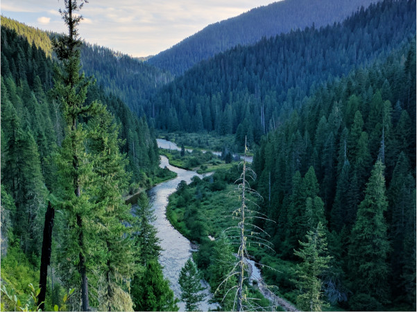
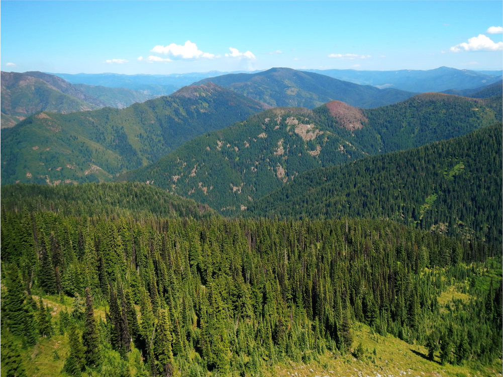
The 260,000-acre Bighorn-Weitas (pronounced “wee-tuss” or “weed-us”) Roadless Area, in the Weitas Creek and Cayuse Creek drainages, is the largest roadless area entirely within the Nez Perce-Clearwater National Forests (NPCNF), a verdant expanse of rainforest-like creek bottoms and windswept peaks. If the Wild Clearwater is the Emerald of the Rockies, Weitas is the Emerald of the Wild Clearwater.
To the Northwest, Weitas is bounded by the North Fork of the Clearwater. This section of the North Fork is free-flowing, a haven for west-slope cutthroat trout. However, it was excluded as a candidate for Wild and Scenic River designation in the 2025 Forest Plan, a reversal of the 1987 plan. Other candidate waterways include Weitas Creek itself and Cayuse Creek.
Weitas is one of the most at-risk wildlands in Idaho. This roadless area, despite its ecological importance, magnificent opportunities for solitude, and vital role as a carbon sink, is not recommended for wilderness protection by the U.S. Forest Service, nor is it protected from development under the Idaho Roadless Rule. Two bills have included Weitas or portions of it for wilderness designation, though none have passed.
Weitas is directly adjacent to five other large roadless areas, in the center of the Clearwater Wildlands Complex. It’s aptness for wilderness designation cannot be overstated.
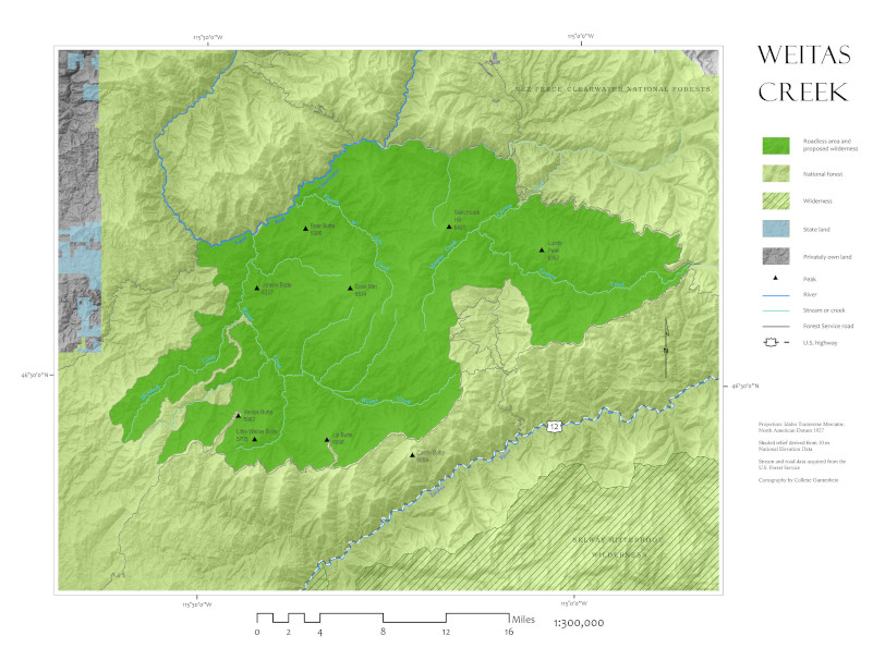
Weitas is located on the Clearwater National Forest between the North Fork of the Clearwater to the northwest, the Toboggan Ridge Road to the northeast, and the Lolo Motorway to the South. It is adjacent to six other roadless areas: Great Burn/Kelly Creek (east), Moose Mountain (northeast), Mallard-Larkins (north), Pot Mountain (northwest), Fish and Hungery Creeks (south), and Weir Creek (southeast).
Both Weitas and Cayuse creeks drain into the North Fork of the Clearwater. This section of the North Fork is free-flowing, and eventually drains into Dworshak Reservoir.
Geology
Most of the area is composed of granitic formations. Coarse-grained quartz menzonite of the Cretaceous Idaho Batholith, coupled with gneiss and rhyolite, create highly erosive soils here. However, there are few large, exposed areas of rocky and barren ground. Mountaintops are mostly rounded and deeply weathered. In some places, much older rocks over a billion years old can be found, like siltite, gneiss, and schist.
Ecology
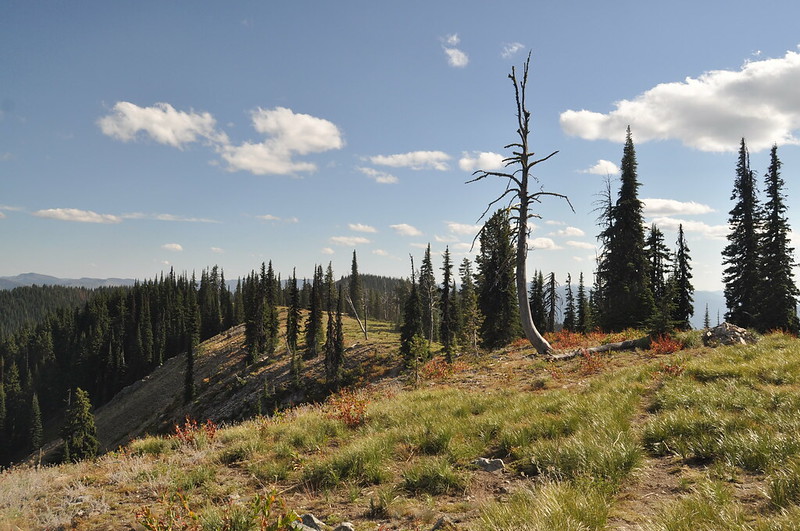
Weitas lies near the southern end of the North American inland temperate rainforest. This 600-mile-long arc of moist forests begins in eastern British Columbia and ends in north-central Idaho. Indeed, Weitas is one of the wettest places in the Gem State, receiving over 60 inches of precipitation annually.
Even in summer, the area is humid and often cloudy. Large wildfires are rare, the result of extraordinary weather events that occur every few centuries. Enormous burned cedar snags, legacies of the 1910 fires, can still be found in the area.
This wet climate supports cedar-hemlock-pine forests at low elevations (2300-4000 feet). Grand fir and western red cedar dominate in stream bottoms above understories of swordfern, wild ginger and fool’s huckleberry.
At the higher elevations, (5,000-6,500 feet) one finds spindly carex and beargrass, mountain hemlock, and even-aged lodgepole pine, their slender trunks shooting upwards in defiance of the forest fires that induced their growth.
Within conifer stands, stretch large brush fields and grass meadows create winter forage for ungulates. Roughly 18,000 acres provide crucial winter range for elk.
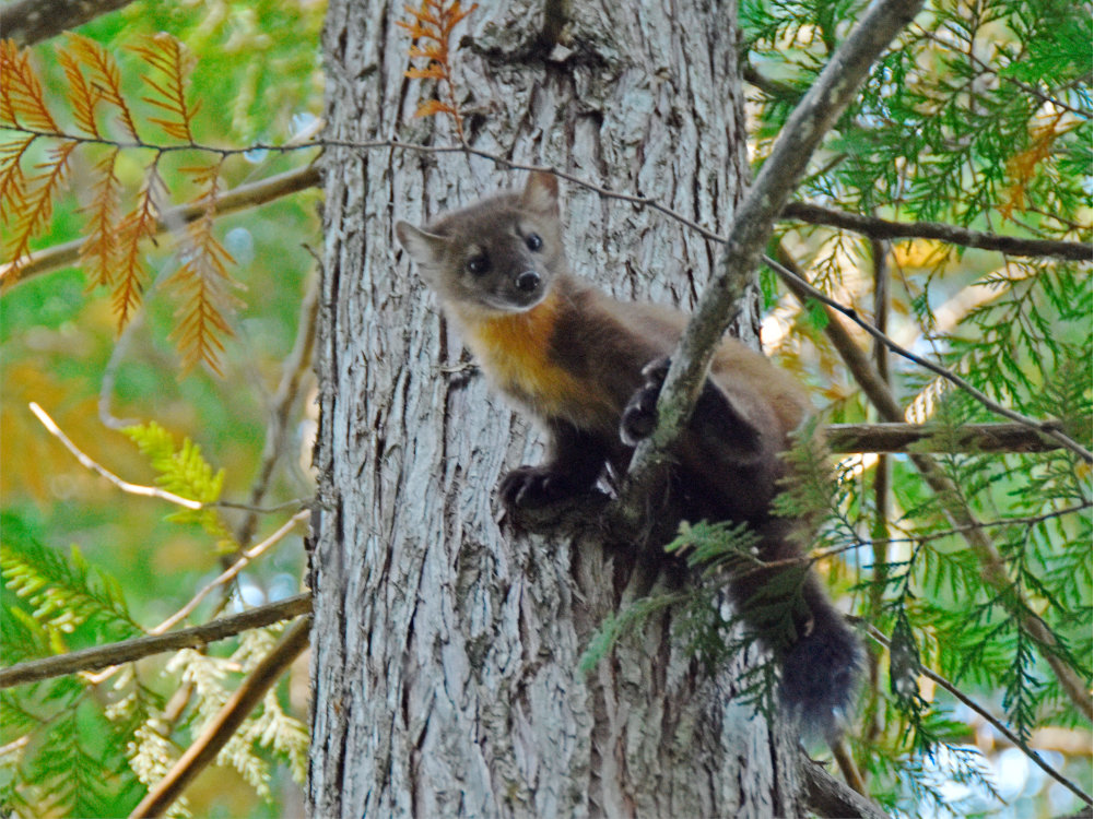
Wildlife abounds in this low-elevation country. Red squirrels, red-tailed chipmunks, and pygmy shrews (the smallest mammal in North America) scurry along the forest floor. Black bear are abundant, feasting on carpenter ants that inhabit rotting grand fir logs. Mule deer, moose, and mountain goats can be found here, as well as a wide variety of forest carnivores, like wolves, fisher, and northern goshawks.
Grizzly bears, though unconfirmed, may be recolonizing the area. In previous years, the U.S. Fish and Wildlife Service acknowledged the high-quality grizzly habitat in the North Fork country.
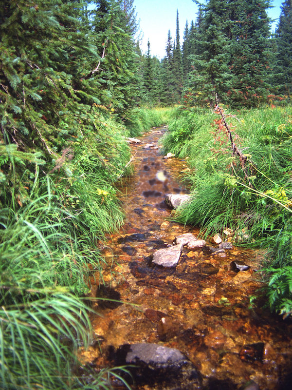
Bull trout and west-slope cutthroat trout thrive in the cold, clear streams of the area. A catch-and-release regulation was established in Cayuse Creek in 1974 for the protection and enhancement of cutthroat; Cayuse Creek has a regional reputation as an excellent fishery.
Dworshak Dam, constructed near Orofino, Idaho in 1973, entirely blocks salmon and steelhead from accessing the North Fork of the Clearwater, including the Weitas and Cayuse drainages, a serious loss to the area. However, the waterways of the Weitas area still contribute to salmon survival. In hot summers with low water, cold water from Dworshak is released into the main Clearwater to reduce temperatures downstream. This temporarily alleviates the harm caused by warm water temperatures in the slackwater, created by the dams, on migrating salmon and steelhead in the Snake and Columbia Rivers.
The Lolo Trail marks the southern boundary of the area. This trail is on both the National Historic Landmark and National Historic Trail registries. Long a fundamental prehistoric route connecting the Columbia Basin and Great Plains peoples, the trail was also traversed by Lewis & Clark.
Later, Nimiipuu leader Chief Joseph and the band of non-treaty Nez Perce traveled the trail toward Canada, attempting to escape persecution during the Nez Perce War of 1877.
In addition to this landmark, nine other prehistoric sites and fifty-seven historical sites have been located just outside, or in some cases within the region, including Forest Service lookouts, cabins, and Lewis & Clark expedition campsites, among others.
This remote area provides abundant opportunities to enjoy solitude and serenity among some of the largest intact old growth left in the entire Clearwater Basin. Opportunities for hiking, backpacking, primitive camping, horseback riding, hunting, and stream fishing are abundantly provided. Among the wide, rounded ridges of the drainages and tributaries visitors will find solitude and a sense of isolation in the verdant wild.
In 1993, much of the roadless area was included in a bill sponsored by Idaho congressman Larry LaRocco. All of Weitas Creek is included in the visionary Northern Rockies Ecosystem Protection Act, or NREPA.
Although not recommended for wilderness designation in the 1987 Clearwater National Forest plan, a 1993 settlement agreement has kept most of the area managed as potential wilderness for over 30 years. The Forest Service has suggested if this area is designated as Wilderness, the unmaintained 555 route beyond the Weitas Guard Station bridge be incorporated in the Wilderness.
Under the Clearwater National Forest Travel Plan (2012) Weitas Creek was opened to off-road motorized use, threatening to exacerbate erosion-prone soils, displace wildlife, and disturb the primitive serenity.
In the 2025 Nez Perce-Clearwater National Forests land management plan, the Bighorn-Weitas roadless area was not recommended for wilderness designation. It was only analyzed for wilderness in one alternative.
Weitas, Fourth of July, and Cayuse Creeks are ideal candidates for protection under the Wild and Scenic River Act. The North Fork of the Clearwater, though it shares many of the extraordinary values that would suggest its protection, was dropped in the 2025 plan from consideration, reducing protections in the area. The weak standards of that plan, along with misinformed efforts to log away the threat of wildfire, make the possibility of industrial logging in the Weitas area greater now than ever.
That would be an enormous loss for Idaho. As a fish and wildlife haven, a powerful carbon sink, and source of solitude, this vital place must be protected as wilderness.