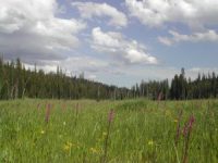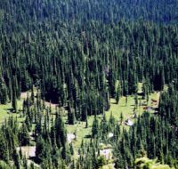
49 Meadows is approximately 100 acres in size and 15 miles south of Avery, Idaho. In 2010 FOC worked with Fred Rabe, Palouse Great Old Broads for Wilderness and White Pine-Idaho Native Plant Society to establish this RNA on the Idaho Panhandle National Forests. This rare sub-alpine peatland ecosystem consists of forested, scrub/shrub, and herbaceous mats along with temporal ponds and spring streams (Meadow Creek). This creek contains habitat for Bull trout and Westslope Cutthroat, and is a tributary of the Little North Fork Clearwater. Dominant vascular plants found in the meadow include firethread sedge and cottongrass. We identified over two dozen macro-invertebrates while preparing our report to the Forest Service. We also observed sites in the meadow formerly occupied by beavers.
Bureau of Land Management Areas of Critical Environmental Concern
In 2006, the Bureau of Land Management (BLM) issued a Resource Management Plan and Environmental Impact Statement, asking for comments to preserve lands east of Grandmother Mountain. In 2007, the BLM selected Pinchot Marsh and Lund Creek as a Research Natural Area/Area Critical Environmental Concern (ACEC). The agency, unfortunately, left out Breezy Saddle, Lookout Mountain, Crater Peak, and Long Hike Peak in their selection. Within an ACEC, special management attention is required to protect and prevent irreparable damage to important historic, cultural or scenic values, fish and wildlife resources, or other natural systems and processes. Note: National Forest lands overlap with the two areas below.

Pinchot Marsh is located south of Orphan Point on Road 301 out of Clarkia, Idaho. The marsh is approximately 40 acres, at an elevation of 5,440 feet. It consists of small, slow-moving streams draining the marsh to form Pinchot Creek, which eventually joins Floodwood Creek to the south. Sedges dominate the vegetation with an understory of sphagnum moss. Long-tailed salamanders and spotted frogs, together with several species of macroinvertebrates, are located here.

The upper reach of Lund Creek is within the ACEC. The lower reach crosses National Forest lands before merging with the Little North Fork Clearwater River. Bull trout and Westslope Cutthroat trout spawn and rear successfully in Lund Creek. Sub-alpine peatlands (bogs and marshes) containing a mix of plant species common to western mountain systems, come together with taxa typical of boreal habitats in the far north. Widow Mountain forms a backdrop to the entire drainage.
Go back to main Research Natural Area page.