There are few places in America as wild as Meadow Creek. Why isn't it designated wilderness?
Wilderness designation is a legislative process that rarely follows what is actually wild or wilderness on the ground. For example, the western boundary of the Selway-Bitterroot Wilderness, a designated wilderness, forms the eastern boundary of the Meadow Creek Roadless Area, an unprotected public wildland.
In effect, Meadow Creek is physically connected but politically cut off from the Selway-Bitterroot Wilderness. This area, however, remains a remarkable piece of wild country and a strong candidate to become an addition to the Selway-Bitterroot Wilderness.
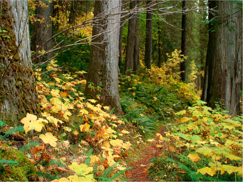
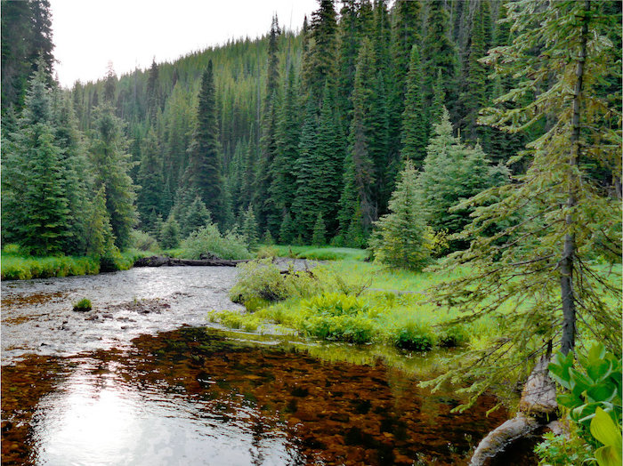
Meadow Creek is the largest tributary of the Selway River. The Meadow Creek waterway is diverse, sometimes gliding transparent over granite cobbles, sometimes tumbling (and absorbing oxygen) in rapids, and sometimes resting in deep, cold pools. This diversity, along with a lack of logging in all but a tiny fraction of the watershed, makes it one of the best watersheds in Idaho for salmon, steelhead, west-slope cutthroat, and bull trout.
Fire is a regular part of Meadow Creek’s ecology, and recent fires have made the area important forage for elk and nesting for migratory birds. It is a popular destination for backpacking, fishing, hunting, and horseback riding.
The 2025 Nez Perce-Clearwater National Forests Plan recommended the eastern third of the roadless area to be protected as wilderness, and motorized access in the western side. We believe all of this irreplaceable landscape should become (politically) part of the Selway-Bitterroot Wilderness.
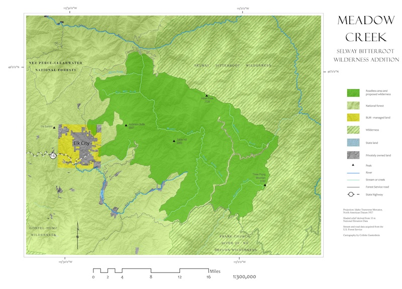
Meadow Creek is a roadless area just East of Elk City, Idaho on the Nez Perce National Forest. It contains the lion’s share of the Meadow Creek watershed, which flows north to the Selway River, as well as acreage in the South Fork of the Clearwater and Salmon River watersheds. At 215,000 acres, it is the largest possible addition to the Selway-Bitterroot Wilderness (SBW) and a strong candidate for wilderness designation.
The Selway and Salmon are Wild and Scenic Rivers, while the South Fork and Meadow Creek itself would make good additions. Running Creek, a tributary of the Selway, enters the Selway-Bitterroot Wilderness near Parachute Ridge, while Bargamin Creek, a tributary of the Salmon, enters the Frank Church-River of No Return Wilderness near the Southern Nez Perce Trail.
It is bounded to the south by the Magruder Corridor, across which lies the Frank Church-River of No Return Wilderness. To the east and northeast is the Selway-Bitterroot Wilderness, and to the west by developed portions of the Nez Perce National Forest. The northern boundary of the roadless area is the Falls Point/American River road (FS Road 443), close to the confluence of Meadow Creek and the Selway River.

GEOLOGY
Much of Meadow Creek is within the Idaho Batholith, a series of granitic mountain formations from the cretaceous period, specifically the Challis formation. Older formations with schist, quartzite, and gneiss in the Upper Missoula Group.
Unlike most watersheds in the Northern Rockies, the headwaters of Meadow Creek were not glaciated in the last glacial maximum. This has protected more developed soils in high mountain meadows, a unique feature that supports diverse plant communities.
ECOLOGY
With elevations ranging from 1,800-8,200 feet, there are several different habitats in the area.
Western red cedar and grand fir are prominent in creek bottoms throughout the area, with ponderosa pine and Douglas fir found mid-slope, and lodgepole pine and sub-alpine fir at the highest elevations. Payson’s milkvetch, Idaho douglasia, candystick, clustered lady’s slipper, banks monkeyflower, and evergreen kittentail are Region One sensitive plant species. Pacific yew trees can be found within the 500-acre Warm Spring Creek Research Natural Area (RNA), located near the confluence of Warm Springs Creek and Running Creek.
The Meadow Creek Roadless Area is considered the most important fishery of any roadless area on the Nez Perce portion of the Nez Perce-Clearwater National Forests. Due to intact habitat and pristine water quality, healthy populations of westslope cutthroat, steelhead, rainbow trout, and bull trout exist throughout the drainage. Summer Chinook still make their journey from the ocean to the clean and cold tributaries within this roadless area. Removing the Lower Snake River Dams would greatly expand the populations of anadromous fish in this watershed.
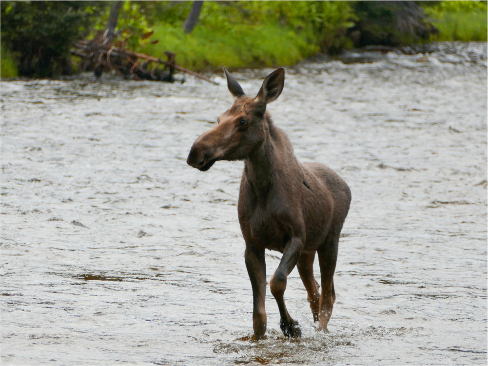
Gray wolves, wolverines, fishers, and black bears inhabit Meadow Creek, with habitat available for grizzly bears and lynx. The status of the latter two species is unknown, although it is believed Canada lynx still inhabit the area and grizzly bears have been confirmed near the area. The roadless area contains important summer range for elk and winter range for moose, with mule and whitetail deer also finding forage in this highly productive and dense forest. The Coeur d’Alene salamander, the Columbia spotted frog, and the western toad can also be found by those who take the time to carefully and meticulously search for these rare species.
RECENT FIRES
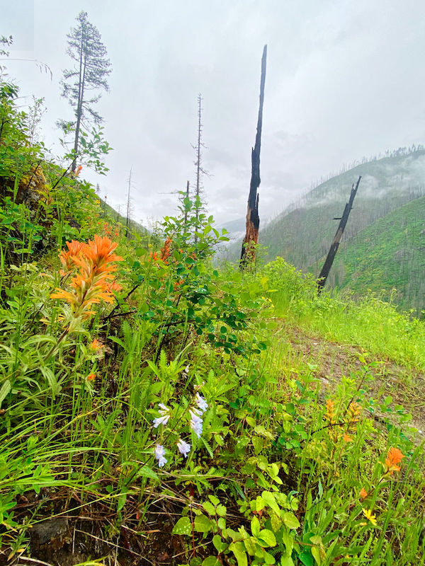
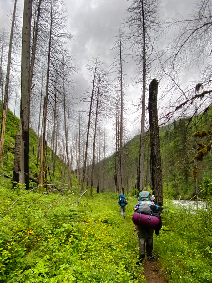
Those who have visited Meadow Creek recently have likely seen the impacts of recent fires. While large wildfires can seriously harm human communities, the wildlands of Idaho have evolved alongside them.
In fact, snag forests, the acres of standing dead trees in recently burned areas, are one of the most biodiverse forest types, second only to old growth.
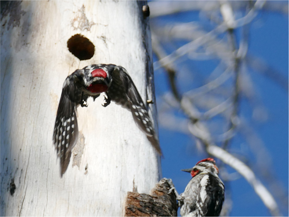
Dead trees attract insects—some can even sense high temperatures and travel toward the fire—which explode in population. These sustain birds, fish, and other wildlife. As insects bore through decaying wood, black-backed and pileated woodpeckers tear after them, making holes that other birds will nest in.
Without tree cover, early-successional plants have taken root, like fireweed, silvery lupine, redstem ceanothus, and Western huckleberry. Lodgepole pine, whose cones open during fire, are quick to overtake them, as are Sitka alders. Eventually, depending on the climate, the snag forest may develop into open meadows, or ponderosa parkland, or wetter fir-spruce forests.
Fish can be negatively affected temporarily by the sediment run-off after fires. However, fires also increase the complexity of waterways by adding dead trees and branches, which benefits young fish. Fish evolved with with "pulse" disturbances like fire, which are beneficial for fish habitat in the long term. Roads, on the other hand, are chronic "press" disturbances, which are harmful.
Fire in roadless areas managed in different ways throughout the country. The Forest Service has a policy to allow natural fires to burn here because fighting fire in such a remote area is extremely difficult. However, the agency engaged in an expensive and futile effort to control most of the fires in the Meadow Creek Roadless Area.
The Southern Nez Perce Trail, used for centuries to travel between the Clearwater Region and western Montana, crosses the southern part of the roadless area. It was expanded as the Magruder Trail, used by miners, and eventually graded as the Magruder Corridor (FS Road 468).
Meadow Creek roadless area, in conjunction with the neighboring Selway-Bitterroot and Frank Church-River of No Return Wildernesses, may well offer greater solitude, tranquility, and ruggedness than any other area in the Lower 48. Backpacking, day hiking, hunting, fishing, birding, and wildlife viewing opportunities are abundant in this primitive recreational paradise.
The potential Meadow Creek holds when it comes to wilderness designation cannot be overstated. A portion of the region was protected as part of the old Selway Primitive Area in the mid-1900s. Even the Forest Service recognized the value of this area when studying it for wilderness potential in the 1970s.
Unfortunately, politics interfered and recommendations by the Forest Service to protect the area as wilderness were overturned at higher levels. Despite public support, the area was not included as an addition to the Selway-Bitterroot Wilderness when the Central Idaho Wilderness Act was passed in 1980. That legislation established the River of No Return Wilderness and made an addition to the Selway-Bitterroot Wilderness in the upper Selway River system.
The 2025 Nez Perce-Clearwater Forest Plan recommends the eastern third of Meadow Creek as wilderness, an improvement from the 1987 Nez Perce Forest Plan, which included none of the area. However, this draft plan outlines increased motorized use in other parts of the area, which would harm its sensitive wildlife and wilderness character. FOC advocates for the entirety of the roadless area to be designated as wilderness.
Despite our best efforts, the BLM, which manages a small amount of public land in the Clearwater Basin, recently allowed logging on the fringe of this roadless area, in small uninventoried areas that should be considered part of the IRA.
Friends of the Clearwater
PO Box 9241
Moscow, ID 83843
(208) 882-9755